Magellanic
southern beech
Nothofagus betuloides grows in the region’s forests and alongside lenga in the mixed woodlands of Brunswick. It is a characteristic presence in the wooded landscapes bordering parts of the strait. [5]

CHILE · MAGALLANES AND CHILEAN ANTARCTICA REGION
01 — THRESHOLD
From the shore, it seems an expanse of water and sky. On a map, it is a winding seam between the continent and Tierra del Fuego. The Strait of Magellan brings these scales together: the intimacy of a bay and the reach of a passage that changed world history.
02 — GEOGRAPHY
The strait connects the Atlantic and Pacific at the southern end of South America. Its waters separate mainland Patagonia from Isla Grande de Tierra del Fuego and the islands farther west. DIRECTEMAR gives its length as 330 nautical miles between Punta Dungeness and the Evangelistas islets: roughly 611 kilometres of navigation through changes of course, narrows and open reaches. [1]
The shores offer no single, uniform landscape. In the east, steppe horizons and low coasts leave the wind free to travel great distances without shelter. Farther west, mountains and islands draw the view inward. Water reaches between steep landforms, while snow picks out the higher ground. A satellite image makes this transition apparent at a glance. [2]
This variety is why understanding the strait takes more than following its outline. A beach near Punta Arenas, the landscape of Primera Angostura and a western inlet belong to the same passage, yet offer very different experiences. The water connects them; each shore’s distinctive character gives the whole its richness.
Primera Angostura, Segunda Angostura and Paso Tortuoso are among the principal navigational challenges. Currents, tidal variations, changes of heading and weather require local knowledge and careful planning. The shores provide some protection from the open ocean, alongside the particular demands of a narrow passage. [3]
On deck, a current may be felt before it becomes visible. From land, moving clouds can change the water’s colour in minutes. This variability is part of the place: the landscape becomes clearer when we watch it change, as the same coast turns bright, grey or almost invisible over the course of a day.
On the Brunswick Peninsula, Cape Froward marks the southern tip of the South American mainland. Islands, channels and other routes continue farther south. Cape Horn belongs to a different geographical setting, open to the ocean, and deserves a reading of its own. [4]
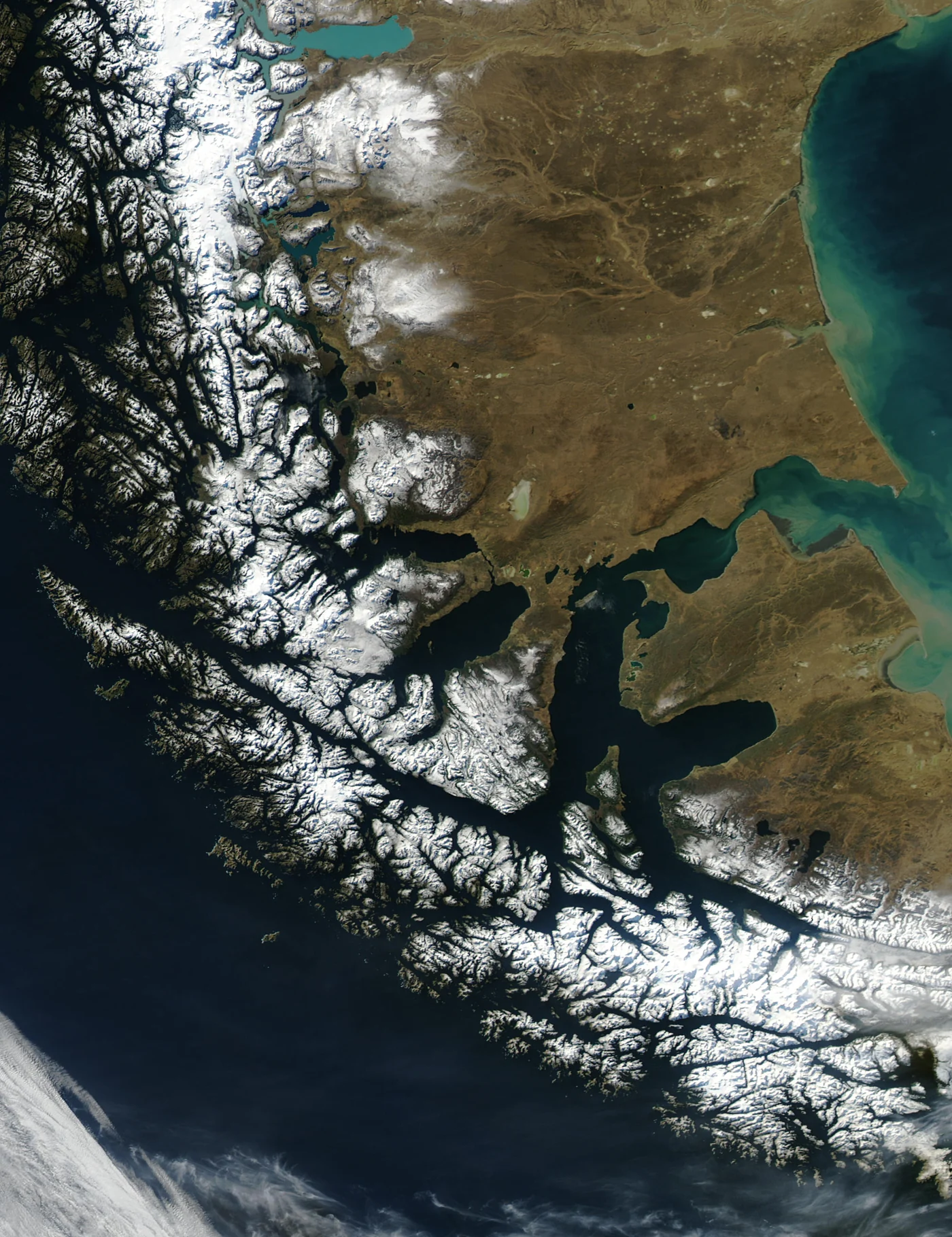
THE LAND FROM ABOVE
The satellite view reveals the continuity of the passage and the contrast between open country in the east and the intricate mountains and islands of the west.
The image shows the terrain. Sovereign boundaries are established by treaties; they cannot be inferred from the colour of a coastline.
03 — FLORA
Forests, grasslands and wetlands offer different ways of inhabiting these southern shores.
Nothofagus betuloides grows in the region’s forests and alongside lenga in the mixed woodlands of Brunswick. It is a characteristic presence in the wooded landscapes bordering parts of the strait. [5]
Lenga, Nothofagus pumilio, and ñirre, Nothofagus antarctica, are part of the Magellanic vegetation mosaic. [5]
Around the Santa Ana Peninsula, calafate, michay and leñadura grow alongside species of Nothofagus. Looking for these plants along the trails adds another dimension to a visit often centred on historical monuments. [6]
The Magellanic steppe supports far more plant diversity than the image of an endlessly repeated grassland suggests. Research at the Universidad de Magallanes shows the importance of wet meadows, wetlands and other habitats within this open landscape. [7]
SOIL AND WATER
In the forests and shrublands near the strait, attention can begin with something small: a trunk, a leaf, a flower beside the trail. The Santa Ana Peninsula brings history and vegetation into particularly close contact. A few steps from sites recalling the establishment of the Chilean Republic’s presence, the forest keeps a different sense of time. Parque del Estrecho has also identified native orchids on its land, an invitation to look closer to the ground. [8]
Near Punta Arenas, Reserva Nacional Magallanes offers an introduction to Brunswick’s mosaic of forest and peatland. Its vegetation includes lenga and Magellanic southern beech associations, as well as mossy areas. [5]
Peatlands accumulate plant matter under conditions that slow decomposition. The balance between accumulation and loss determines their relationship with carbon. Temperature, water saturation and microbial activity influence that balance; conserving their value means preserving the conditions that allow them to function. Regional research points to questions that remain unresolved about their rates of accumulation. [9]
A wetland may look like a gap between the forest and the coast. Seeing it as an ecosystem changes that impression: stored water, small plants and soil are parts of a single process. Staying on designated trails allows us to observe it without turning a brief visit into lasting disturbance. [5]
04 — FAUNA
In the Francisco Coloane protected area, the humpback whale, Megaptera novaeangliae, plays a central part in an important ecological relationship. Its feeding habitat is among the conservation targets established for this marine area. Magellanic penguin breeding grounds, South American sea lion colonies and kelp forests are also protected. [10]
A whale at the surface reveals only a fragment of this life. Protecting its habitat means looking beyond what a photograph usually captures: the waters where it feeds and the relationships supporting the wider ecosystem. Watching wildlife from a boat means briefly sharing a space on which another living being depends.
Monumento Natural Los Pingüinos encompasses Magdalena and Marta islands. Protecting Magellanic penguin nesting grounds is central to the area’s conservation history. On Magdalena, penguins share their surroundings with cormorants, skuas and other seabirds. Visits follow designated routes and take place through authorised boat services. [11] [12]
The abundance visitors see varies with species’ life cycles and local conditions. Writing about nature must allow for that variation: no journey can promise an encounter with a wild animal.
The Santa Ana Peninsula supports coastal birds and forest species such as thorn-tailed rayaditos and house wrens. Sea lions and Peale’s dolphins may be seen from the shore. These encounters connect environments that visitors often explore separately: the woodland trail and the water’s edge. [6]
On Brunswick, Reserva Nacional Magallanes records culpeo and chilla foxes, rodents and occasional pumas at higher elevations. Peatland habitats support birds such as upland and ashy-headed geese. Location matters: an account of regional wildlife must distinguish forest, wetland and coast, without implying that every species lives everywhere along the strait. [5]
Kelp forests, including those formed by Macrocystis pyrifera, provide habitat and food for many coastal organisms. Chile’s Ministry of the Environment recognises them as an aquatic ecosystem type. Near the strait, research in Bahía Inútil documents a rich macroalgal community associated with giant kelp. Biodiversity extends beyond what the surface allows us to see. [13] [14]
Conserving this submerged landscape also protects connections with human activity. Magellanic kelp forests shelter species important to the regional economy and cuisine, a relationship that has encouraged protection initiatives within small-scale fisheries. [15]
05 — INDIGENOUS PEOPLES
The Kawésqar language belongs to the seafaring world of western Patagonia. Its southern variety extended from Muñoz Gamero to the Strait of Magellan. Names, stories and words preserve a distinctive way of understanding this territory. [16]
The Aónikenk travelled the steppe between the Santa Cruz River and the strait. Knowledge of hunting grounds and campsites shaped their movements; the later introduction of horses transformed their mobility. [17]
Their society was organised around hunting and gathering territories known as haruwen, associated with lineages and a complex ceremonial life. Chilean Law 21.606 recognised the Selk’nam people in 2023; their members and descendants are part of the present. [18]
The Yagán world is chiefly associated with the Beagle Channel and the islands farther south. Distinguishing it from the peoples of the strait helps reveal the diversity of the far south. Their homeland will be essential to understanding Cape Horn. [19]
In the Kawésqar world, canoes enabled travel through channels, access to marine resources and the establishment of camps on sheltered shores. Life depended on attentive knowledge of the water and its margins. The Museo Chileno de Arte Precolombino documents these practices and a culture whose complexity encompasses language, technology and worldview. [20]
The histories of the mainland also call for precision. Expanding livestock ranching restricted Aónikenk lands and changed their possibilities for movement. In Tierra del Fuego, the Selk’nam suffered persecution, deportation and catastrophic population loss during colonisation. Their histories cannot be reduced to a scene set before towns were founded. [17] [18]
In this article, recognising Chilean sovereignty and acknowledging Indigenous territories are complementary tasks. A rigorous national history can explain territorial titles and institutional presence while also addressing the lives of earlier inhabitants and the harm accompanying the region’s economic incorporation. Memory gains depth when it holds both dimensions in view.
Explore the Indigenous peoples →06 — HISTORY
Ferdinand Magellan’s expedition crossed the strait in 1520, sailing for the Spanish Crown in search of a route to the Spice Islands. The voyage linked Atlantic navigation with the Pacific and formed part of the first circumnavigation, completed by Juan Sebastián Elcano in 1522 after Magellan’s death. [21]
The significance of that voyage belongs to world history. The existence of a homeland already known and inhabited by Indigenous peoples belongs to an older history. Holding both perspectives allows us to describe the European event without turning it into the beginning of human life in the far south.
Pedro Sarmiento de Gamboa attempted to establish Spanish settlements to control the passage. In 1584 he founded Nombre de Jesús and Rey Don Felipe. Supply difficulties and the breakdown of the enterprise led to tragedy: the latter settlement became known as Puerto del Hambre. Its ruins preserve the memory of that occupation. [22] [23]
Puerto del Hambre prompts reflection on the distance between an imperial ambition and the conditions needed to sustain life. Archaeology offers a reading of the settlement beyond its name and the stories handed down by sailors. [24]
Manuel Bulnes’s government entrusted Domingo Espiñeira, the governor of Chiloé, with organising an expedition to Magallanes. Commanded by Juan Williams Wilson, also known as Juan Guillermos, the schooner Ancud carried from Chiloé the people who would establish a permanent presence for the Republic. On 21 September 1843, possession was taken in Chile’s name. [25]
This is also a Chiloé story: shipbuilding, crew and families sustained a difficult undertaking. Venancia Elgueta and Ignacia Leiva took part in the expedition. Remembering them broadens an account that often focuses on officials and commanders. [26]
Fuerte Bulnes was inaugurated on 30 October 1843. The Republic’s occupation continued with the colony’s transfer to Punta Arenas in 1848, consolidating a base for settlement and regional development. Immigration, livestock ranching and land concessions subsequently transformed Magellanic society. [27] [28]
The city and the strait belong to the same story: a coastal presence became everyday life, work and community. That continuity gives human substance to the dates. At the same time, disputes over land and Indigenous displacement demand close attention to the consequences of this process. [28]
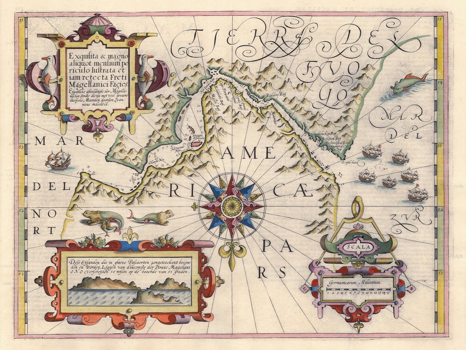
CONTEXT — ROUTES AND GEOPOLITICS
The strait’s strategic importance begins with its position between two oceans and the life it connects around Punta Arenas. Shipping, southern connectivity and the responsibilities of the state bring together geographical, economic and political dimensions. In this editorial reading, its value is best understood through the relationship between navigation, regional development and care for the territory.
Geopolitical interest rests within an established legal framework. On 3 September 2026, Argentina’s presidency published the two governments’ joint communiqué, recognising that the 1881 and 1984 treaties remain fully in force and establish Chilean sovereignty over the entire strait. Comparing the official publications of both countries helps distinguish this agreement from interpretations circulating about it. [32]
Chilean sovereignty, the regime of free navigation and cooperation with Argentina should be read together. Political statements sit within obligations agreed by both states; the treaty articles and this page’s legal section provide the references for that reading.
On 21 September 2026, five Chilean senators signed a declaration in Punta Arenas concerning Chile’s exclusive sovereignty, compliance with the treaties and the region’s right to develop its trade. The Senate also reported proposals concerning connectivity, the state’s presence and the needs of the far south. This is evidence of political debate at that date, distinct from the documents establishing the strait’s legal regime. [33]
Understanding a route means distinguishing its location, navigational conditions and legal regime. A geographical comparison helps clarify the discussion. The actual choice of passage depends on the vessel, its ports of departure and destination, and operating conditions. The mere existence of a maritime alternative does not allow us to calculate its future use.
A natural interoceanic passage under Chilean sovereignty. [1]
An engineered canal connecting the Atlantic and Pacific through locks; its official inaugural transit took place in 1914. [34]
A cape associated with an ocean route that DIRECTEMAR distinguishes from the passage through the strait. [3] Explore Cape Horn →
The ocean passage south of Cape Horn separating South America from Antarctica. [35]
07 — CHILEAN SOVEREIGNTY
The entire Strait of Magellan is under Chilean sovereignty. Its foundations combine the Republic’s presence, international treaties and the continuous exercise of maritime responsibilities. Understanding those foundations allows the position to be stated precisely. [1] [31]
Article II of the 1881 Boundary Treaty established the mainland boundary north of the strait, assigning the territory south of that line to Chile. Article III provided for the division of Tierra del Fuego and the allocation of islands. Together, these provisions form a basis of Chile’s territorial title. [29]
Article V guaranteed navigation for ships of all flags and the permanent neutralisation of the strait, with an obligation concerning fortifications or defences that could undermine those purposes. These conditions form part of its legal regime and of the commitments Chile must fulfil. [29]
Article 10 of the 1984 Treaty of Peace and Friendship defined the boundary at the eastern end along the line between the Hito Ex-Baliza Dungeness and Hito I Cabo del Espíritu Santo markers. It provided for Argentine sovereignty to extend eastwards and Chilean sovereignty westwards, preserving the regime established by the 1881 treaty. Argentina also undertook to maintain unimpeded transit to and from the strait through its jurisdictional waters. [30]
The regime permits international passage while leaving the strait’s status as Chilean territory intact. DIRECTEMAR describes it as lying entirely within Chilean jurisdiction. Navigational safety takes practical form through traffic rules, pilotage, reporting and coordination of vessel movements. These are tangible, daily responsibilities on a route open to the world. [1] [3]
On 3 September 2026, the governments of Chile and Argentina issued a joint communiqué reaffirming the full force and definitive character of the 1881 and 1984 treaties. They expressly stated that those instruments establish the Republic of Chile’s sovereignty over the whole strait. This bilateral declaration reinforces a position grounded in law and shared by both states. [31]
From Patrimonium’s editorial perspective, strengthening that sovereignty also means caring for the territory Chile inhabits and administers: supporting research, valuing Magellanic communities, safeguarding heritage and conserving ecosystems. The national connection becomes stronger when knowledge of a place accompanies recognition of its boundaries.
08 — CONSERVATION
The maritime passage and its surrounding ecosystems occupy the same space. Conserving them requires understanding their connections.
Management of Francisco Coloane brings together different conservation targets: whale feeding grounds, bird and sea lion breeding, and kelp forests. This diversity calls for care of the habitat sustaining the species. [10]
The area’s governance includes public agencies and users, linking protection with human activities through shared responsibilities.
In peatlands, the carbon balance depends on ecosystem conditions. Studying them helps us understand both their contribution and the uncertainties that remain. Protecting water and soil is part of that work. [9]
Keeping to designated routes turns that care into a practical part of a visit.
The Kawésqar language preserves knowledge of the territory and requires efforts to document and pass it on. Contemporary recognition of the Selk’nam people also recalls the persistence of communities long described as having disappeared. [16] [18]
The strait’s heritage includes that living presence.
09 — EXPLORING
Watching the water, ships and horizon helps reveal a city’s relationship with its maritime passage.
Fuerte Bulnes, Puerto del Hambre and nature trails offer different perspectives on the same coast. [6] [23]
Checking visiting conditions, using authorised operators and staying on the trail allows visitors to approach the birds’ landscape without intruding on it. [12]
The climate and the passage’s characteristics shape every journey. Up-to-date maritime information is part of preparing for it. [3]
10 — ESSENTIAL QUESTIONS
Geography, sovereignty and memory address different questions and help illuminate one another.
Yes. The whole strait is under Chilean sovereignty. The treaties of 1881 and 1984 underpin its regime, expressly reaffirmed by both governments in September 2026. [31]
Sovereignty remains Chilean. Passage for ships of all flags forms part of the international regime established for the strait, which Chile must respect. [1] [29]
They are different routes. The strait passes between landmasses; the Cape Horn route is an ocean passage farther south. DIRECTEMAR distinguishes the two alternatives. [3]
The Kawésqar are associated with the western channels, the Aónikenk with mainland Patagonia and the Selk’nam with Tierra del Fuego. The Yagán world is chiefly connected with the Beagle Channel and the southernmost archipelago. [16] [17] [18] [19]
Its conservation targets include humpback whale feeding grounds, breeding areas for Magellanic penguins and South American sea lions, and kelp forests. [10]
Its interoceanic position connects with navigation, transport links and the development of Magallanes. Chilean public debate also links its sovereignty to the state’s presence and international responsibilities. [33]
Magellan is a natural maritime passage in southern Patagonia. Panama is an engineered canal in Central America that uses locks. Their locations and operating conditions differ. [34]