← PATAGONIAPATRIMONIUM · CUADERNOS DEL SURSOURCES
Rocky Cape Horn headland and an albatross above the ocean

CHILE · 56° SOUTH · SOUTHERN ARCHIPELAGOS

CAPE
HORN

Where the ocean opens the horizon
and memory still has a home.

Photograph: Liam Quinn · CC BY-SA 2.0 · Resolution adapted by Wikimedia Commons.

01 — THRESHOLD

Where land
becomes sea

At Cape Horn, the coast ceases to feel like an edge. Rock rises from the water, the wind shifts between islands, and the ocean fills almost the entire horizon. The landscape seems to end, yet its connections reach on through the Fuegian channels towards Antarctica.

The cape lies at the southern tip of Hornos Island in Chile, close to latitude 56° south. It belongs to the island group protected by Cabo de Hornos National Park. To the south lies the Drake Passage, the broad ocean gateway between South America and the Antarctic Peninsula.

These places operate at different scales. The cape is a headland; Hornos is an island; the national park protects an archipelago; and the Cape Horn Biosphere Reserve covers a much larger area of land and sea. Puerto Williams, on Navarino Island, is the administrative capital of the Cabo de Hornos municipality and a gateway to the region.

The phrase ‘the end of the world’ speaks of distance. For those who have lived and sailed here, this territory is also home, a route, a place of memory and a meeting ground.

Geography: Armada de Chile · Protected areas at different scales: MMA and UNESCO.

56° SApproximate latitude of the cape
63,093 haCabo de Hornos National Park
1945Establishment of the national park
2005UNESCO Biosphere Reserve designation

02 — WATER AND TIME

A horizon
in motion

The geological separation of South America and Antarctica gradually opened a marine corridor. The Drake Passage belongs to that deep history: tectonic shifts and ocean circulation changed the connection between continents and helped reshape the climate of the far south.

Today, the Antarctic Circumpolar Current flows through the passage, connecting the major ocean basins around Antarctica. Its strength reflects the winds and a complex interplay of water density, seabed topography and pressure differences.

At the surface, the cape faces swells and weather systems that travel across vast stretches of sea. Limited shelter, powerful gusts and rapidly changing conditions help explain its reputation among sailors.

Imagining a visible line dividing two oceans here makes a continuous system look deceptively simple. Pacific and Atlantic waters communicate through currents, water masses and eddies. Their names organise the map; the sea keeps moving.

Deep time: British Antarctic Survey · Ocean circulation: Marshall and colleagues, 2015.
Black-browed albatross above the ocean off Cape Horn
Albatross off Cape Horn · Liam Quinn · CC BY-SA 2.0.

03 — PLANT LIFE

Growing close
to the ground

The southern forest varies in height and continuity. Sheltered sites, exposed slopes and waterlogged ground offer plants very different conditions.

EVERGREEN

Magellanic
southern beech

Nothofagus betuloides. A characteristic tree of the wet southern forests. In the park it grows in low stands and patches interspersed with open vegetation.

WET FOREST

Winter's bark

Drimys winteri. A member of forest communities alongside Magellanic southern beech. Recognising it reveals how the rainforest extends into the southern archipelagos.

LOCALISED OCCURRENCES

Antarctic beech and
leñadura

Nothofagus antarctica and Maytenus magellanica. CONAF records these trees in small parts of the park; their presence does not imply an even distribution across all the islands.

OPEN LANDSCAPE

Cushion plants
and peatlands

Low-growing plant communities, coastal grasses and peatland vegetation complete the mosaic. From a distance they appear to form an unbroken cover. Close up, they reveal many ways of growing.

Stunted vegetation is one way of occupying ground exposed to wind and persistent moisture. Looking only at tree height overlooks much of the diversity that sustains this landscape.

The park's species and vegetation: CONAF. Botanical and island context: Rozzi, Charlin, Ippi and Dollenz, 2004.

04 — MINIATURE FORESTS

A wealth of life
seen through a hand lens

A tree trunk can hold a landscape. Mosses, liverworts and lichens cover its bark with a complexity invisible in the distant view.

The Magellanic subantarctic ecoregion is a global centre of bryophyte diversity. UNESCO reports more than 450 moss species and over 300 liverwort species: together, more than 5% of the world's known bryophytes. These figures concern the ecoregion and its conservation context; they are not an inventory of Hornos Island.

Mosses and liverworts are small plants with a different organisation from trees. Lichens, often found beside them, are partnerships involving a fungus and a photosynthetic organism. The idea of ‘miniature forests’ encourages us to notice their diversity without overlooking these distinctions.

On Navarino Island, Omora Ethnobotanical Park has made such observation part of research, education and ecotourism with a hand lens. A change of scale alters the experience of the far south: what matters may lie just centimetres above the ground, requiring attention rather than a long journey.

It also changes what we understand as natural heritage. Small organisms, damp bark and the water sustaining their habitat deserve care even when they do not appear in a panoramic photograph.

Regional diversity: UNESCO MAB · Research and ecotourism: Instituto de Ecología y Biodiversidad · The researchers' perspective: Rozzi and colleagues, Diversidad y belleza.

05 — PEATLANDS

Ground that
holds water

Peatlands are wetlands in which plant material accumulates faster than it decomposes, forming peat. Water, temperature and limited oxygen in the soil shape that balance. Ground that looks firm can conceal soft, saturated layers that grow slowly.

In southern landscapes, these communities combine small plants, waterlogged patches and compact vegetation. Their value reaches beyond appearance: they store carbon and help regulate water. Mapping by Chile's Ministry of the Environment identifies peatlands as a major land cover within the park.

Protecting them means attending to their structure. Making a track, draining the ground or disturbing a wet surface changes the relationships between water, plants and soil. Recovery does not happen within the span of a tourist season.

The Cape Horn International Center studies greenhouse gas exchanges in subantarctic forests and peatlands, including differences between habitats and the effects of invasive species. This monitoring matters because stored carbon and wetland emissions depend on different processes. Understanding them takes measurements, rather than an image of an apparently untouched landscape.

Land cover and ecological functions: MMA · Cabo de Hornos National Park · Research: CHIC · Sentinels of Climate Change.

06 — ANIMAL LIFE

Lives between
air and water

Wildlife makes sense within its habitats. Islands, shores, channels and the open ocean provide different resources; they do not all support the same species.

ARCHIPELAGO AND SHORE

Birds along the edge

CONAF records the striated caracara (Phalcoboenus australis), kelp gull (Larus dominicanus) and southern giant petrel (Macronectes giganteus) in its account of the park. The photograph on this page shows a black-browed albatross off the cape.

A bird may seem suspended above the water, but it is moving through a space used for feeding, travel and rest. A viewpoint offers a momentary scene; understanding a population means studying seasons and movements.

CONAF · Liam Quinn's photographic record.

SOUTHERN WATERS

Marine mammals

Sea lions and cetaceans belong to these environments. CONAF's records include Peale's dolphin (Lagenorhynchus australis) and the Chilean dolphin (Cephalorhynchus eutropia).

A species recorded in the region is no guarantee of an encounter on a boat trip. Sightings depend on the location, conditions and animals' behaviour. Keeping a respectful distance prevents observation from becoming pursuit.

CONAF · Wildlife.

NAVARINO · REGIONAL CONTEXT

The forest has a voice too

At Omora, research includes birds such as the Magellanic woodpecker (Campephilus magellanicus), thorn-tailed rayadito (Aphrastura spinicauda) and white-crested elaenia (Elaenia albiceps), alongside less conspicuous aquatic organisms.

Those records relate to Navarino's habitats. They broaden our understanding of the Biosphere Reserve, but should not automatically be applied to Hornos Island. Habitat variety is part of the region's richness.

IEB · Omora Park.

07 — THE SUBMERGED FOREST

The coast
continues below

From a boat we see the surface. Beneath it, kelp forests add another dimension to the territory.

Subantarctic shores support forests of large brown algae, including giant kelp, Macrocystis pyrifera. Their structures create habitat and support feeding, breeding and shelter for numerous organisms. Associated wildlife depends on conditions that vary between sheltered channels and exposed coasts.

Regional research examines the diversity of these communities and their responses to changes in light, salinity and temperature. Meltwater and mixing make comparisons between fjords and the ocean-facing coast particularly revealing.

Seaweeds also connect biodiversity with human livelihoods. Species important to fisheries, including sea urchins and southern king crabs, use these habitats. Marine conservation must therefore consider habitats, resources and the people who work at sea together.

The underwater forest's architecture moves with the water. Its value lies in the relationships it makes possible. The visible cape is only part of a landscape whose greatest extent remains submerged.

CHIC · Seaweeds and Magellanic biodiversity · Rodríguez and colleagues, 2024.

08 — YAGHAN TERRITORY

Before
Hoorn

The European name arrived in a territory that already had inhabitants, knowledge and its own ways of finding a path.

Historically, the Yaghan world was connected with the channels south of Tierra del Fuego, from the Beagle Channel to the Cape Horn archipelagos. Navarino, Hoste and the southern islands formed a maritime space travelled by canoe and along the shore.

The report of Chile's Historical Truth and New Deal Commission describes a canoeing people whose life connected sheltered places, shores and marine resources. Reading this territory means letting go of the assumption that water necessarily separates. It also links places, carries people and makes a return possible.

Archaeology documents a long history of settlement in the region. Its remains must be interpreted in context; they do not justify identifying every ancient site uncritically with a present-day community. The depth of human occupation and the history of the Yaghan people are connected, but they are not interchangeable categories.

Recognising Yaghan presence here does not erase other southern peoples. The Kawésqar, Selk'nam and Haush had distinct territories and histories, with contacts between them. ‘Fuegian’ is a broad geographical term, not the name of a single language or culture.

Territory and contacts: Historical Truth and New Deal Commission · The Yaghan · Archaeological context: Museo Territorial Yagan Usi.

09 — LIVING WITH THE SEA

The canoe
and the fire

Bark canoes brought together knowledge of materials, construction and navigation. They carried people and belongings, provided access to resources and linked camps. Choosing a landing place could not be separated from the weather, shelter and opportunities to find food.

Fire was part of daily life in camps and could be kept aboard on a base protecting the canoe's structure. Historical accounts also describe shellfish gathering, diving undertaken by women and the hunting of marine animals. These practices relied on experience, cooperation and learning.

To understand this technology, we need to see the whole system. Bark, timber, fibres, tools and knowledge of the water were bound up with social life. A canoe was more than a way to cross a distance: it helped sustain a way of inhabiting the world.

FUCOA's publication on the Yaghan brings together history and accounts shared by community members. Hearing these voices moves the narrative beyond outside observers alone. Memory has authors: the people passing on a story also decide what to share and how to tell it.

Ancestral life and accounts: Gleisner y Montt · Yagán, FUCOA, 2014 · Historical context of subsistence: Memoria Chilena · Yámanas.

10 — ENCOUNTERS AND UPHEAVAL

The cost
of contact

Growing maritime traffic, missions and colonisation profoundly altered the lives of southern Indigenous peoples. For the Yaghan, introduced epidemics and territorial change accompanied a severe population decline. Changes in settlement and practice cannot be separated from that unequal relationship.

Explorers' and missionaries' accounts preserve valuable information, as well as the assumptions and prejudices of their time. An old description is not a neutral view. Reading it critically means asking who is observing, what they seek and whose voices are absent.

Today the Yaghan people maintain community life, memory and efforts towards revitalisation. The loss of speakers and historical harms demand attention; they do not confine their descendants to a closed past.

The return of objects from the Gusinde collection to Puerto Williams offers another relationship with heritage. An initial ceremony in 2019 returned three pieces, as part of a process followed by further restitutions and community participation. The objects are once again close to families who recognise their uses and histories. There they can support teaching, dialogue and cultural continuity.

Historical transformations: Biblioteca Nacional · Memoria Chilena · Restitution and participation: Museo Territorial Yagan Usi and Servicio Nacional del Patrimonio Cultural.

11 — THE EUROPEAN ROUTE

A name
on the map

On 29 January 1616, Willem Schouten and Jacob Le Maire's expedition documented its passage around the cape aboard the Eendracht.

They named it Kaap Hoorn, after the Dutch town of Hoorn. The Spanish form ‘Hornos’ reflects the name's transformation. For European navigation, the voyage opened an alternative route between oceans south of the Strait of Magellan.

The date marks a chapter in European exploration and commercial navigation. Human history here goes back much further. Recognising that distinction helps us understand the event without rendering earlier inhabitants invisible.

The route around the cape became part of long-distance trading networks. Its hardships entered ships' logs, charts and crews' memories. A sailing course was also a sequence of decisions: make use of favourable conditions, find shelter or accept a delay.

The cape's reputation thus brings geography and experience together. Wind has a physical history; a crew's fear, skill and recollections belong to another scale. Both meet along routes that look deceptively simple on a map.

Date, expedition and place name: Chilean Navy · Commemoration of 1616 · Maritime and historical context: FUCOA · Yagán.

12 — CHARTS AND PERSPECTIVES

To survey
is also to change

In the nineteenth century, the voyages of the Adventure and the Beagle produced hydrographic surveys and descriptions of southern coasts. Philip Parker King and Robert FitzRoy took part in these expeditions. Charles Darwin joined the second voyage of the Beagle, which began in 1831.

Mapping improved knowledge of channels, anchorages and coasts. It also consolidated a way of representing the territory through names, measurements and documents that circulated far from the places described.

The expeditions' history includes deeply unequal relationships with Fuegian inhabitants. In 1830, FitzRoy took four Indigenous people to England in an episode of capture and displacement; three later returned to the region. They deserve recognition as people experiencing uprooting, rather than as a colourful footnote to a naturalist's voyage.

Collections and archives allow those perspectives to be re-examined. Today, research can engage with the territory through different questions: who participates, who keeps the materials and how knowledge returns to communities. The accuracy of a nautical chart and respect for local memory involve different responsibilities, but both can be upheld.

National Library of Chile · King, FitzRoy and the Adventure and Beagle expeditions.

13 — MARITIME MEMORY

Routes change.
Lives leave a trace.

An engineering work, a monument and a lighthouse express three ways of relating to southern navigation.

1914 · A NEW PASSAGE

The Panama Canal

The canal opened on 15 August 1914, providing an interoceanic connection that shortened many routes. It changed the choices available to maritime trade and the role of long voyages around South America.

Cape Horn retains its place in ocean sailing, expeditions and maritime imagination. Transport networks change; the headland still faces the sea.

Panama Canal Authority.

1992 · REMEMBRANCE

The steel albatross

The Monument to the Unknown Sailor, by José Balcells, was inaugurated on Hornos Island on 5 December 1992. Its albatross figure commemorates those who lost their lives at sea.

The silhouette invites a pause before the landscape. Understanding its meaning takes us beyond the image of the triumphant navigator and makes room for absence.

Chilean Navy · Monument anniversary.

AN EVERYDAY PRESENCE

Light and listening

The lighthouse and the local maritime authority form part of the maritime assistance and monitoring system. Weather information and communications connect the island with vessels and coordination centres.

Behind the symbolism of a distant outpost lies everyday work. Living and operating here demands continuity, attention and a practical relationship with southern weather.

Chilean Navy · Maritime presence and assistance.

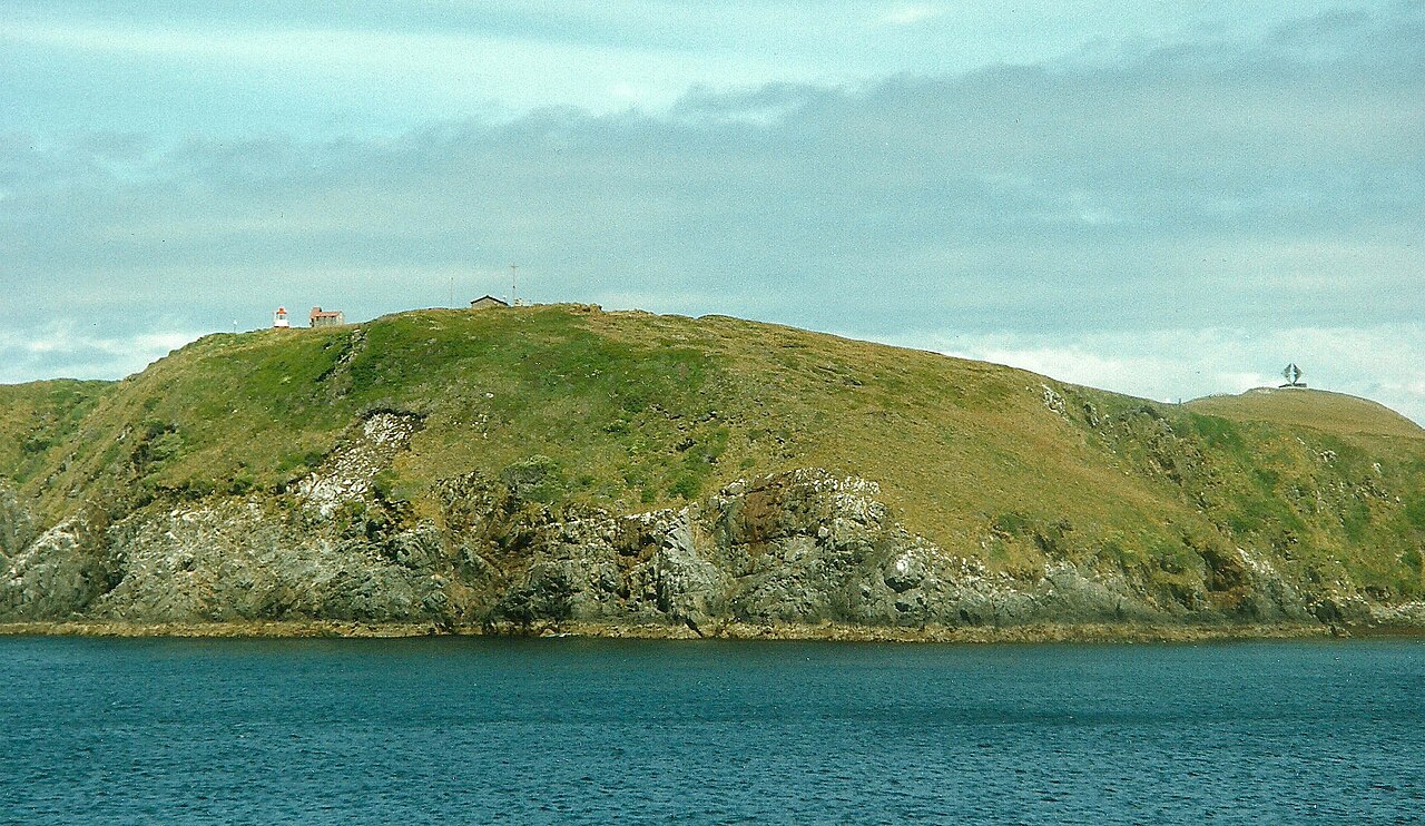
Rocky shore of Hornos Island, showing the lighthouse and albatross monument in 1994
Hornos Island, 1994 · Historical photograph by Aah-Yeah · CC BY 2.0. A period record, not a current verification of the facilities.

14 — CONSERVATION

Caring for
connections

Cabo de Hornos National Park was established on 26 April 1945 and protects 63,093 hectares, including islands of the Wollaston and Hermite groups. The Biosphere Reserve designation in 2005 added a scale of conservation bringing together terrestrial ecosystems, marine environments and human communities.

A biosphere reserve seeks to connect conservation, research and sustainable ways of living. Its designation does not mean that the entire area shares a national park's rules, or that its landscapes are immune to global change.

Research at Cape Horn addresses responses to climate, biodiversity and introduced species. In the region, the effects of invasive mammals on birds and aquatic habitats show that remoteness does not ensure protection. Records must be tied to particular islands and dates: a problem documented on Navarino does not automatically describe every part of the park.

Biocultural conservation connects this care with languages, knowledge and relationships with territory. Involving communities in research and decisions broadens the meaning of heritage. A landscape includes organisms, processes and inhabitants; protecting it requires attention to how they sustain one another.

National park: MMA · Biosphere reserve: UNESCO · Research and biocultural conservation: CHIC.

15 — THE PRESENT

The territory
still speaks

In Puerto Williams, getting to know the region also means listening to those who keep its memory alive.

The Yagan Usi – Martín González Calderón Territorial Museum adopted its name and a new exhibition in 2024, following dialogue with the community. The exhibition connects ancestral history, changes in the territory and the continuing life of the Yaghan people.

Basketry, navigation objects and words from the language appear as connections with people and knowledge. Martín González Calderón's name honours a cultural practitioner and leading figure in canoe navigation who worked with the museum.

Including this present changes the way we travel through the far south. A visit can bring together landscape, archives, science and conversation, while recognising that some memories are public and others belong to families and communities. Listening does not grant access to everything or make another person's experience ours to stage.

Cape Horn's history continues in these spaces. It does not end with a ship in 1616, a nineteenth-century chart or a monument: it is still being made by those who live here.

Yagan Usi Territorial Museum · 2024 renewal.

16 — TRAVELLING WITH CARE

A journey also
learns to wait

NAVIGATION

Accept the weather

Hornos Island is reached by sea, and landing depends on conditions. An itinerary may change; consulting the maritime authority and operator is part of preparing for the journey.

GROUND

Stay on the boardwalk

Keeping to authorised routes protects vegetation and reduces exposure to wet, slippery surfaces. Wind requires attention even on short walks.

WILDLIFE

Give animals space

Observe without feeding, touching or pursuing animals. Following guidance and keeping your distance avoids disrupting their activities and preserves the meaning of the encounter.

COMMUNITIES

Listen with respect

Acknowledge the people behind stories and knowledge. Ask before photographing anyone or entering community spaces; choose experiences agreed with those taking part.

Park access and care: CONAF · Navigation: Armada de Chile. Check current conditions and regulations before travelling.

THE INHABITED EDGE

The horizon opens.
Memory remains.

Cape Horn can be seen as a rocky headland or as a meeting of scales: a plant holding water, a bird above the swell, an ocean route, a canoe and a word passed on once more.

Understanding it means holding these images together. The far south cannot be measured by distance or the difficulty of arrival alone. Its depth lies in the lives and histories connected by the sea.

17 — ESSENTIAL QUESTIONS

Keep
exploring

Distinctions that help us read the territory without confusing its scales.

Is Cape Horn the southern end of mainland South America?

It is on an island. Mainland South America's southernmost point is Cape Froward, on the Brunswick Peninsula; the Diego Ramírez Islands lie farther south than Hornos.

Are Cape Horn and the Drake Passage the same place?

No. The cape is a headland on Hornos Island; the Drake Passage is the ocean corridor between South America and Antarctica. Rounding the cape and crossing the Drake Passage towards Antarctica are different journeys.

Which Indigenous people is directly associated with these archipelagos?

The Yaghan, historically connected with the channels south of Tierra del Fuego. Their communities and revitalisation efforts are part of the present.

Are miniature forests found only on Hornos Island?

No. The term describes small communities of mosses, liverworts and lichens in the subantarctic region. The ecotourism programme using hand lenses takes place at Omora, on Navarino Island.

Are the national park and the biosphere reserve equivalent?

No. The national park is a specific protected area. The biosphere reserve covers a much larger territory of land and sea, with conservation, research and sustainable development objectives.